Understanding property, people and places starts with geography—and in Australia, that begins with Mesh Blocks. Mesh Blocks are the building blocks of spatial analysis, underpinning how data is organised, mapped and interpreted across the country, forming the foundation for countless data-driven decisions.
Table of Contents
Jump ahead ↓
What are Mesh Blocks?
As defined by Australian Bureau of Statistics (ABS), mesh blocks are the smallest geographical area of the Australian Statistical Geography Standard (ASGS) and ABS’s classification of Australia into a hierarchy of statistical areas.
Mesh Blocks are essentially a set of geographic boundaries designed to segment Australia into very small areas. These boundaries are used to apply a systematic grid over the entire country, dividing it into tiny sections called Mesh Blocks.
Each Mesh Block is a polygon that outlines a specific piece of land, which can range from a single block in a city to a vast, sparsely populated area in the countryside.

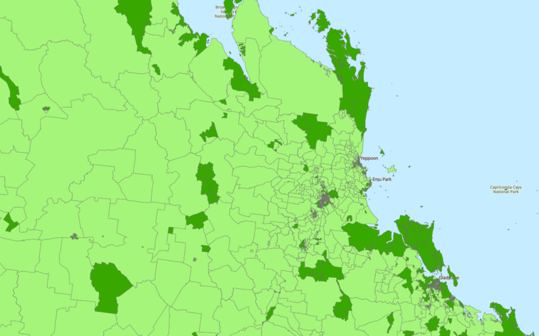
Mesh Blocks covering the whole of Australia. Source: ABS Maps
Mesh Block Design
Mesh Blocks for the current ASGS Edition 3 are designed according to a standard set of design criteria first developed for ASGS 2011.
Most Mesh Blocks are designed to contain 30 to 60 dwellings, although some low dwelling count Mesh Blocks exist. They are permitted in order to account for other design criteria.
The reasons for the minimum dwelling count of Mesh Blocks is so they’re small enough to aggregate to a wide range of areas, allow comparisons between geographic regions but also prevent accidentally exposing confidential information of individuals or businesses.
Mesh Block Updates
Mesh Blocks are updated (or redesigned) every 5 years to stay relevant.
Mesh Blocks for the current ASGS Edition 3 was redesigned to ensure it still meets the design criteria first developed for ASGS 2011 and reflects the growth and change in Australia’s population, economy and infrastructure.

Example of Mesh Block change along the border of Queensland and New South Wales. Source: Australian Bureau of Statistics
How are Mesh Blocks Created?
Each Mesh Block is assigned a unique numerical code or identifier. This code is used to reference the Mesh Block in statistical databases and geographic information systems (GIS).
The format of the code can vary but often includes digits that signify hierarchical levels of geography.
In Australia, Mesh Block identifiers are 11-digit codes.
The 11-digit Mesh Block code comprises: State and Territory identifier (1 digit), and a Mesh Block identifier (10 digits).
How are Mesh Blocks Used?
Mesh Blocks are the smallest geographic area that the ABS provide statistics against, so it offers population and dwelling counts at a hyper-local level – this is particularly useful for Census analysis.
These geographic boundaries allow for the aggregation of data from individual Mesh Blocks into larger geographic units, such as suburbs, towns, cities, and regions. This hierarchical structuring makes it possible to analyse data at various levels, from very detailed local information to broader regional or national trends.
The ABS does not and cannot provide detailed segmentation data (Census data) that can be directly connected to individuals or businesses. Instead, they provide anonymised and aggregated data against geographic areas.
Most businesses looking to augment their analysis with population segmentation data will adopt Mesh Blocks as their default level geographic unit to gain the highest level of accuracy. The popularity of Mesh Blocks mean many businesses will use it for geographic statistics regardless of whether or not the Census data is being leveraged.
Mesh Blocks Use Cases
Mesh blocks are versatile and have many commercial uses. Some sample use cases include:

How to Incorporate Mesh Blocks into Datasets
Incorporating mesh blocks into datasets involves several steps to ensure seamless integration and effective utilisation of geographical information. Here’s a guide on how to incorporate mesh blocks into datasets.
More Intel from Data Army


The Fastest Way to Improve Location Analytics Isn’t Better Models. It’s Better Address Data
Intel In Your Inbox
Sign up to our newsletter and receive our latest knowledge articles, practical guides and datasets.